When I saw the Kaskaskia Dragon mentioned online after a google search of tourist attractions along i70 I knew I HAD TO SEE IT. A 35 foot long dragon hand made out of metal that shoots fire out of it’s mouth? Not even a question – we were going to see it.
road trip
2017 State High Point Road Trip
I’m not quite sure why it has taken me so long to blog about my road trip with my dad – we had such a great time and ended up getting 8 state highpoints in like 6 days – I really doubted it was possible. This blog post is going to be an overview of the entire trip – I will write an entire post for each highpoint (eventually).
My dad and I studied the map for all the highpoints and decided to head out and get as many as we could with the time we had. It was rainy when we left and I just threw everything in the car right after work and took off to meet my dad. We had been on the road for about 2 hours when I realized I forgot all the dry food I had packed – I grabbed the cooler, but the bin w/ all the bread, cereal, etc was still on the dining room table. CRAP! Well, I figured we could just grab what we needed along the way, there was no point in going back for it.
Cape Cod Rail Trail
I have been wanting to bike the 22 mile Cape Cod Rail Trail in Massachusetts since I saw it earlier this year in an article about the best rail trails by the beach (or something like that). I was hooked – I wanted to bikepack to Nickerson State Park or some other campground along the trail, but was unable to get a campsite. My parents decided they wanted to come along too so my bikepacking trip turned into just a long bike ride – which was fun!
The GPS said it would be a 6 hour drive, but with traffic it turned into about an 8 1/2 hour drive. We checked into the hotel near the start of the trail in Dennis and were lucky to get a room on the 1st floor so we could keep our bikes in the room (no elevator). I honestly have no idea what we did after we checked in – I think I just went to bed and my parents went and got ice cream and walked around a bit. Why does a long car ride make you so tired??
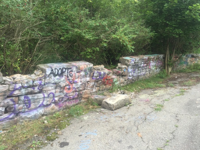
Centralia’s Graffiti Highway
On the way back from my camping trip to Watkins Glen we stopped off in Centralia, PA – this is a whole town that was evacuated due to a fire that started in the Coal Mine below. The fire has been burning since 1962. Some people didn’t want to leave, but eventually most of them were forced out. I am always surprised at how many people come to see this — well — area of nothing but shrubs, weeds and cemeteries – there was even a person selling hotdogs at a stand on the side of the main road (that’s a new one).
You can wander around the abandoned roads and hope to see smoke that still escapes from the cracks in the pavement and dirt to this day, although to be honest each time I go there, there is less and less smoke visible. We didn’t see any on this hot summer day. I am going to go back in the winter because supposedly you can see it better then so I’ll talk more about the town in that post.
Watkins Glen State Park
Watkins Glen State Park is one of my favorite places to visit. The campgrounds are wonderful, bathrooms are clean with flush toilets and running water, and the hiking trails are great. The best trail is called the Gorge Trail and is the one that everyone comes to hike. The trail is carved right into sides of the gorge and goes up over 800 steps over about a mile and a half. It goes over, under and through 19 waterfalls along the way. Although the waterfalls weren’t flowing as much as I have seen in the past, it was still an extremely beautiful place to visit!

the bottom of the gorge trail

natural heart

Mount Mansfield Strike 2
Kevin and I got up early to pack the final things we would need for our trip and put them in the truck. We gave Willow (my cat) her insulin shot and set out for Stowe, VT to try to hike Mt Mansfield before they closed the toll road at 5- I knew we would be cutting it close and my heart sunk when I punched the address into the GPS and saw the estimated arrival time was 3:30- that was over an hour what my phone GPS said!! “We’re not gonna make it” I said – it takes approx 20 mins to drive up the toll road – plus let’s say 2 hrs to hike and enjoy the views and then 20 mins to drive back down- the website says all cars must start driving down by 4:45 at the latest because the gate closes at 5. This did not give us enough time. Kevin said his GPS the time always goes down as he drives. We figured we would give it a try and see if we made it- I wanted to be there by 2 to be safe but knew that just wasn’t possible. On the long drive I started looking for options for plan B.
White Butte – North Dakota State Highpoint – Road Trip Day 6
I can see for miles and miles,
I can see for miles and miles,
I can see for miles and miles and miles and…ok you get the point…I just kept hearing this song by The Who as we drove from Rapid City to Amidon, ND on the way to the high point White Butte. The drive was BEAUTIFUL – you really could see for miles in every direction as the landscape was pretty flat – and we also saw a rogue cow running down the road. Poor guy got out of his pasture somehow!
We followed these instructions from Summitpost.org:
From Amidon, ND:
– Go E on US 85 for 2.0 miles to an unmarked gravel road.
– Turn S (R) on the road and continue on for 5.0 miles to another gravel road.
– Turn W (R) and continue 1.2 miles to the VanDaele’s farmhouse.
There is actually a sign pointing towards the highpoint from 85, but I read on another blog that the road wasn’t the best so we opted to go to the next road, which follows the instructions above. It brings you right to the donation box at the start of the trail. After you place your donation (I read online $10 is the standard amount – the box has a padlock, but it’s open a bit on one side so you can slide the donation in) you can drive down the lane to the gate, but the road is really rutted out so it’s not recommended. Believe me, this would be really tricky to drive down even in an SUV, plus it only adds 2 miles round trip to an already pretty short hike, and the views are gorgeous walking down the lane – ENJOY THEM!

Dontion box

lane to White Butte


Road Trip Day 5 – Rapid City, SD
After reaching Panorama Point, we continued to Rapid City, South Dakota to hang out for a few days – if you have been reading my blog for a while, you know I was in Rapid City last year to see the sights and hike Harney Peak which is the South Dakota high point. My dad had never been to the area so we spent some time exploring.
I LOVE this metal art in the town we drove through on the way to the Crazy Horse Memorial.


Panorama Point Nebraska State Highpoint – Road Trip Day 4
On day 4 of our road trip my dad and I got up early and drove to Panorama Point in Nebraska. I took a screen shot of the directions from summitpost.org because I knew this highpoint was in the middle of a field so I wasn’t sure how much cell reception I would have. The instructions from that web site were perfect and took us right to the highpoint.
From I-80 in NE:
-Take Exit 8, just East of the WY-NE border
-Go S on CR 17 for 10.0 miles until dead-end
-Turn W (R) on CR 8 and continue for 4.2 miles
-Turn S (L) on CR 9 and continue for 1.0 miles
-Turn W (R) on CR 6 and continue for 2.0 miles
-Turn S (L) on CR 5 and continue for 2.0 miles
-Turn W (R) on dirt road with sign, cross double cattle guard (for bison!) and continue for 1.0 miles to a bend to the right (NNW), and continue0.2 miles to the highpoint marker
The road heading back is not paved – expect gravel and stones. You could hear the constant “PING” of them hitting the car and an occasional “KLUNK” of a larger rock. I was holding my breath the whole time – especially near the end where there were a few ruts in the road, making it tricky to drive, but we made it!
This is on private property and the owners ask for a $3 per person donation to visit the summit. There are envelopes and a donation box right at the start of the lane. The owners ask you to not hike down the lane because of Bison on the property (note the strips you have to drive over which Bison will not cross.)


Thank You and What’s Next
Just wanted to say THANK YOU to everyone who has been reading my blog – it has been really awesome to chat with so many people who are into the same interests as I am. 🙂
